Manchester’s geology is a mix of glacial till, alluvial deposits along the Irwell and Medlock, and made ground from centuries of industrial activity. In our experience, this layered variability makes conventional borehole-only investigations risky. Electrical resistivity surveying (VES) gives us a continuous 2D image of the subsurface without disturbing the ground. We routinely run resistivity lines before drilling to map old foundations, buried channels, or contamination plumes. For deeper structure, we combine VES with microtremor HVSR to capture seismic velocity profiles too. The result is a faster, cheaper picture of what lies beneath Manchester’s streets and brownfield sites.
Resistivity imaging in Manchester’s made ground often reveals voids and old foundations that no borehole would catch alone.
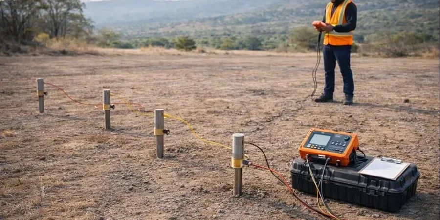
Scope of work in Manchester
The main parameters we record include:
- Apparent resistivity (Ω·m) at each electrode spacing
- Inverted true resistivity model (2D section)
- Estimated depth of investigation (DOI) index
- Anisotropy ratio when using multiple array orientations
Critical ground factors in Manchester
The main risk in Manchester is misinterpretation of made ground. Old brick, ash, and clinker are highly resistive, while wet alluvial clay is conductive. A single 2D line without borehole calibration can mislead. We always pair resistivity surveys with at least one borehole or test pit for ground-truthing. Another common risk — metal pipes or sheet piles create strong artefacts that mask the real geology. We flag these before fieldwork by checking utility records. For sensitive sites near the Rochdale Canal or former gasworks, we also run veleta de campo tests to correlate resistivity with undrained shear strength.
This service complements our laboratory testing work for a complete project analysis.
Our services
We offer two main resistivity-based services in Manchester, each adapted to the local ground conditions.
2D Electrical Resistivity Tomography (ERT)
Multi-electrode continuous imaging for mapping bedrock depth, old foundations, contamination plumes, and groundwater pathways. Typical line length 80–200 m, depth up to 60 m. Includes inversion report and interpreted cross-section.
Vertical Electrical Sounding (VES) for Layered Models
Four-electrode sounding at a single point to determine layer resistivities and thicknesses. Best for simple horizontal geology — glacial till over sandstone, for instance. Output includes a 1D layered model with uncertainty bounds.
Quick answers
How deep can a VES survey reach in Manchester?s glacial till?
With a 40 m electrode spread the VES method typically reaches 10–15 m depth in the till, which is enough to see the boundary with the underlying Sherwood Sandstone. For deeper targets we extend the spread to 80 m or switch to a dipole-dipole ERT array.
Does the made ground in Manchester affect the resistivity readings?
Yes, significantly. Made ground containing brick, ash, and clinker is highly resistive (100–500 Ω·m), while natural alluvial clay is conductive (10–40 Ω·m). The contrast is useful for mapping old foundations but can mask deeper layers if the inversion is not constrained by borehole data.
What is the typical cost range for an electrical resistivity survey in Manchester?
For a standard 2D ERT line (100 m length, 2 m electrode spacing) the cost ranges from £490 to £920 depending on site access, number of lines, and reporting detail. VES soundings at a single point are at the lower end of that range.
How long does a resistivity survey take on a typical Manchester site?
A single ERT line with 50 electrodes takes about half a day for setup, acquisition, and pack-up. A VES sounding at one point takes 1–2 hours. For a full site with multiple lines we usually need 1–2 days on site, plus 3–5 working days for data processing and reporting.