Manchester receives around 1200 mm of rain annually, and the city's glacial till and fluvial deposits overlie Pennine sandstones and Coal Measures shales. That combination of high rainfall and layered geology makes our landslide assessment service essential for any cut, fill, or development on sloping ground. When we evaluate a slope in Manchester, we start by reviewing historical instability records — there are documented failures along the Irwell Valley and in the Bury-Rochdale corridor. Our field team then deploys inclinometers and piezometers to track movement and pore pressure in real time. For deep-seated risks, we correlate borehole logs with resistivity surveys to map slip surfaces without guessing.
We map slip surfaces with resistivity surveys and calibrate limit equilibrium models using direct shear data from the actual failure zone.
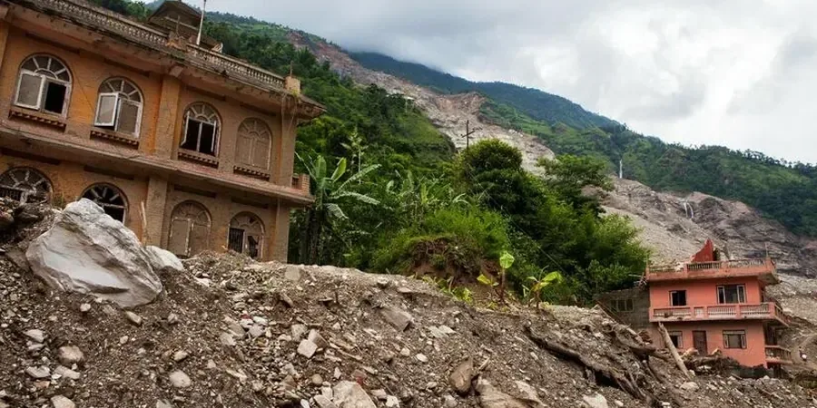
Scope of work in Manchester
Critical ground factors in Manchester
Manchester's industrial expansion in the 19th century carved railway cuttings and canal embankments through steep valleys — many of those assets now sit on softened, weathered slopes. Urban infill and new housing estates in areas like Moston and Blackley are reactivating old shear surfaces that were stable only under drained conditions. Without a professional landslide assessment, cut slopes for a new road or housing platform can creep for years before a sudden failure. We have seen cases where a 4 m high cutting in laminated clay failed during a wet winter, damaging the structure below. The solution is early-stage investigation: install standpipes, run ring-shear tests, and model the slope with multiple seepage scenarios.
This service complements our laboratory testing work for a complete project analysis.
Our services
We deliver site-specific solutions for slope instability in Manchester, from desk study to remediation design. Each service includes field data collection, laboratory testing, and numerical analysis under UK standards.
Slope stability analysis (limit equilibrium & FEM)
We use SLOPE/W and PLAXIS 2D to model circular and non-circular slip surfaces, incorporating pore pressure from monitored piezometers and time-dependent strength loss. Results are delivered as factor-of-safety contours and recommended geometry.
Inclinometer monitoring & shear surface detection
Permanent or temporary inclinometer casings installed in boreholes up to 30 m depth. Monthly or post-storm readings detect displacement as low as 0.5 mm, allowing us to confirm the depth and rate of movement before failure.
Remediation design & drainage planning
Based on the landslide assessment findings, we design horizontal drains, toe berms, soil nailing, or retaining walls. We also specify surface water management to reduce infiltration on vulnerable slopes.
Quick answers
How much does a landslide assessment cost in Manchester?
For a typical residential or small commercial slope (up to 8 m height), the cost ranges between £760 and £2,900 depending on the number of boreholes, laboratory tests, and complexity of analysis. The final quote is tailored to your site conditions.
What are the main causes of landslides in Manchester?
The primary triggers are prolonged winter rainfall (saturating the glacial till), excavation at the toe of existing slopes, and poorly managed surface water runoff. Many historic cuttings in Coal Measures shale have weakened over time due to weathering and root action.
How long does the assessment take from site visit to report?
A standard landslide assessment with one borehole, inclinometer installation, and three months of monitoring takes 12 to 16 weeks. If only a desk study and walkover survey are needed, we can deliver a preliminary report within 10 working days.
Do you follow UK building regulations and Eurocode 7?
Yes. All our analyses comply with Eurocode 7 (EN 1997-1:2004) and BS 5930:2015. We apply partial factors for permanent and variable actions, and we design remediation measures to achieve a minimum factor of safety of 1.3 under worst-case seepage conditions.